Radar has also been used to create topographic data of the Earth’s surface. This is invaluable to archaeologists, whether for mapping or finding new sites, or for understanding the wider …
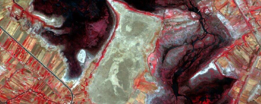
Synthetic aperture radar (or SAR) is the most common type of radar system used in remote sensing that can produce imagery similar to the multispectral images we covered in Week …
Now we are going to introduce you to remote sensing with radar. Last week we noted that only visible light, infrared radiation and radio waves can pass through the atmosphere, …
Normalised difference values are not included when you download multispectral imagery, but they are fairly easy to calculate yourself! We are now going to create an NDVI raster using our …
Landsat 8 & 9 aren’t the only sources of multispectral imagery that you can download and use for free. In this section we will give you a quick summary of …
Now that you have your satellite imagery, let’s get it into QGIS! Adding our image to QGIS Before we open our imagery in QGIS we will need to extract it. …
Now that you have a background of what multispectral imagery is, and how it can be of use to archaeologists, let’s try creating some false colour images! Landsat 8 & …
As you’ve now seen, we can create spectacular pictures using multispectral imagery – but what use is this to archaeologists? In this step we’ll show you how it can be …
We’ve just explored how we can use satellites to collect data on some parts of the electromagnetic spectrum that we cannot see ourselves. At this point you might ask “if …
This week we are going to be introducing you to multispectral imagery. We will explore how satellites can see things using light invisible to the human eye, how we can …
Adding raster data Now that we know the basics of QGIS, we can add our Sentinel-2 imagery. You can continue on with your “World Map” project or start a new …
Last week we told you a little bit about QGIS and why we are using this particular GIS software. Hopefully, you have had a chance to download and install the …
An imaging satellite works in a similar way to a digital camera. Light from the sun is reflected by the Earth and so travels back into space to pass into …
Now that we’ve covered the principles, let’s start learning how to use satellite imagery! We’ll start with finding and downloading imagery from the internet. For this exercise, we’ll be using …